Solomon Islands Feels Earthquake Tremors
By Reema, Gaea News NetworkSaturday, June 26, 2010
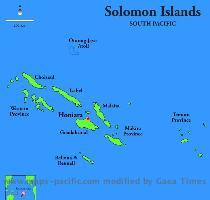
HONIARA, SOLOMON ISLANDS (GaeaTimes.com)- On Saturday evening an earthquake of magnitude 6.9 Richter shook the underwater world off the coast of Solomon Islands. The epicenter of the earthquake was located at a position 206 kilometers southeast of the Pacific nation’s capital Honiara and 58 kilometers southwest of Kira Kira on the Makira Islands. The news of the Solomon Islands earthquake was confirmed by the U.S. Geological Survey (USGS) that has initially estimated the magnitude of the earthquake to be 7.1 Richter. The earthquake took place at around 4:30 pm at a depth of 35 kilometers.
Although there has not been any report of damages done by the earthquake till now, the tremors were enough to frighten the residents of the Solomon Islands who rushed along with their families outside the houses and stood on the street to save themselves. The officials of the USGS said that although the earthquake took place at a depth of 35 kilometers it was felt quite strongly at the capital that is placed 200 kilometers away from the epicenter of the Saturday earthquake.
The officials of the National Disaster Council of the Solomon Islands said that reports from police and other officers from the area closest to the epicenter have not yet been received. The spokesman of the NDC has said to a reliable media source that it has not received any reports of damage or casualties.
The Pacific Tsunami Warning Center said that there is no Tsunami warning for the Solomon Islands. It issued a bulletin where it mentioned that keeping in mind the historical earthquake and Tsunami data the center is issuing no “destructive widespread Tsunami threat”. However it warned that local Tsunami can result from earthquakes of such magnitudes maintaining that the Authorities of the place near to the epicenter should “be aware of this possibility and take action”.
Tags: Honiara, Solomon Islands, United States Geological Survey

